Texas Coastal Ocean Observation Network (TCOON)
In 1988, the National Ocean Service (NOS) and the Texas General Land Office (GLO) entered into a Memorandum of Agreement in recognition of common interests in the determination of tidal datums and other related activities in coastal waters of the State of Texas. The NOS and the GLO began a program of technology transfer to provide GLO personnel with training that would allow the state to conduct its own data collection, analysis and datum computations. The GLO and NOS have continued this partnership to ensure that NOS data collection standards are used and updated with advances in technology.
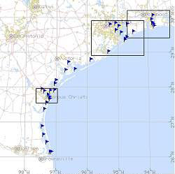
In 1989, the Conrad Blucher Institute for Surveying and Science (CBI) at Texas A&M University-Corpus Christi installed the first state-of-the-art water-level measurement system along the Texas coast in Corpus Christi Bay. Soon after, CBI began the installation of a network of water-level and data-collection platforms along the Texas Coast that became the Texas Coastal Ocean Observation Network or TCOON. In 1991 by legislative mandate, the TCOON became an entity of the State of Texas to facilitate the collection of environmental data for the purposes of studying, planning for, and managing human uses of the Texas Coast. Shortly after the mandate, other agencies such as the Texas Water Development Board (TWDB) and the U.S. Army Corps of Engineers, Galveston District, joined the GLO forming a consortium of stakeholders, all providing funding in support of the TCOON. NOS continues to provide oversight and technology transfer on the development of TCOON and participates in the annual stakeholders' planning meeting.
CBI collects water level, wind speed, barometric pressure, salinity, water quality, and other environmental data from TCOON stations placed in the bays and estuaries along the Texas coast. Data are transmitted every six minutes over the GOES satellite, which also allows NOS to acquire the data through the National Weather Service downlink at Wallops Island, VA. Accessibility to the metadata through CBI’s website enables NOS personnel to validate a number of key attributes. This ensures that TCOON data is compatible with NOS standards and formats. TCOON is the first regional observation system in the country that allows this level of access and quality assurance by NOS. A password-protected section of CBI’s website allows designated NOS personnel access to the most critical quality-control attributes. The success of the TCOON program can be used as a template for many regional observing systems now being initiated across the nation in support of the Integrated Ocean Observation System (IOOS).
NOS selectively incorporates TCOON station data into the NOS database for a variety of applications, but two cases are particularly important. In 2002, NOS used water-level data from a number of TCOON stations in support of an expedited NOAA hydrographic survey schedule that supported the newly created Department of Homeland Security. These surveys could not have been completed on schedule without the support of TCOON. The cost in dollars and manpower to establish this number of water-level stations would have diverted resources from other NOS programs for many months.
The TCOON has also proved invaluable in providing water-level and environmental data to monitor severe coastal storms such as hurricanes. NOS maintains a network of only six permanent stations in Texas; real-time data is available on the Tides Online website (www.tidesonline.nos.noaa.gov). This site displays the available meteorological data and observed and predicted water levels, allowing the user to graphically monitor the changes in observed vs. predicted water levels (referred to as storm surge). NOS transfers this water-level and meteorological data to the National Weather Service (NWS), which uses the data in its severe storm warnings and evacuation guidance. NOS has selectively added TCOON data to its Tides Online website during hurricanes to supplement the data from the permanent stations, providing a greater spatial density of information with which to monitor water levels before, during, and after a storm. This provides a level of data coverage not possible prior to TCOON.
The value in TCOON's use of NOS data collection standards and formats is realized in the ability to display TCOON data on the NOS website with confidence that the data is accurate. The ongoing partnership between NOS, GLO, and CBI over the last 25 years has resulted in enormous benefits to the agencies and to the communities each serves. These benefits will certainly continue to expand with further advances in technology.