St. John's River Operational Forecast System (SJROFS)
The Environmental Fluid Dynamics Code (EFDC) (Hamrick, 1992a; 1992b) has been used to perform operational nowcasts and forecasts for the Lower St. John's River. The EFDC model solves the three-dimensional, vertically hydrostatic, free surface, turbulent averaged equations of motions for a variable density fluid. The physics of the EFDC model and many aspects of the computation scheme are equivalent to the widely used Blumberg-Mellor model (POM).
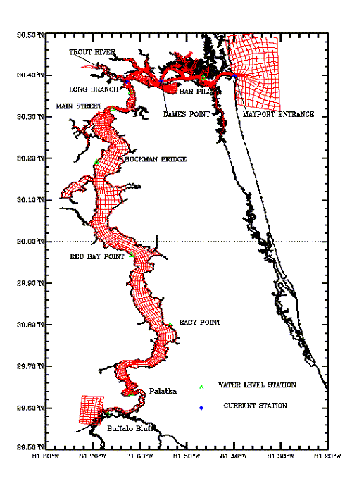
An orthogonal, boundary-fitted, structured grid extending upstream from the Atlantic Ocean near Mayport to Buffalo Bluff (Figure 1) was applied. The model grid is based on a transformed 188 x 105 rectangular computational grid containing 2,210 water cells. Horizontal cell sizes, irrespective of direction, range from 81 - 2,040 m. The model grid generally does not extend up the tributaries to the head of tide, and the model application does not allow for flooding and drying of grid cells. There are six stretched, sigma vertical layers.
For the nowcast, water levels along the open ocean boundary are determined using a correction factor of 1.05 applied to real-time water level observations at the NOAA water level gauge at Mayport, Florida (Station ID 8720218). Water temperature and salinity along the open ocean boundary are derived from real time observations at Mayport. Surface forcing conditions are from forecast products of NCEP's North American Mesoscale (NAM) model. Real-time river discharges along six of the main tributaries entering the St. John's River are downloaded from the USGS as lateral inflows. SJROFS makes a one-hour nowcast every hour.
For the forecasts, along the open ocean boundary, water levels are specified as a superposition of the tide predictions from Mayport and the subtidal water level forecasts at Fernandina Beach, Florida. The latter are made available by the National Weather Service (NWS) as output from their Extratropical Storm Surge Model (ETSS). River discharges at the same station as nowcast are currently persisted from the latest observations. Forecasts of surface wind and air pressure from the NAM-12 model are interpolated onto EFDC model grid as surface forcing. Four daily cycles of 48-hour forecasts are made at 00,06,12,18 UTC.
