Salish Sea and Columbia River Operational Forecast System (SSCOFS)
Oceanographic nowcasts and forecast guidance are scientific predictions about the present and future states, respectively, of a water body. Nowcasts of water levels, currents, water temperature and salinity incorporate recent (and often near real-time) observed meteorological, oceanographic, and/or river flow rate data and/or analyzed (e.g. gridded) meteorological and oceanographic products. A nowcast covers the period of time from the recent past (e.g., the past few days) to the present, and it can make predictions for locations where observational data are not available. Forecast guidance incorporates meteorological, oceanographic, and/or river flow rate forecasts and makes predictions about the future states of a water body. A forecast is usually initiated by the state of a nowcast.
For SSCOFS, both nowcasts and forecast meteorological forcing is provided by NCEP's North American Mesoscale (NAM) weather prediction model. The model relies on the National Water Model output for the river forcing, ADCIRC (ENPAC2015) for the tidal forcing and the Global Real-Time Ocean Forecast System (G-RTOFS) for the subtidal water level, water temperature and salinity profile along open boundaries.
The near surface currents displayed on the time series and animation graphics are generated from the output at the second layer from the top. The winds displayed are from 10 m above the sea surface.
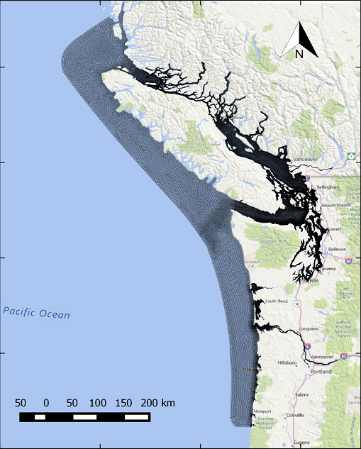
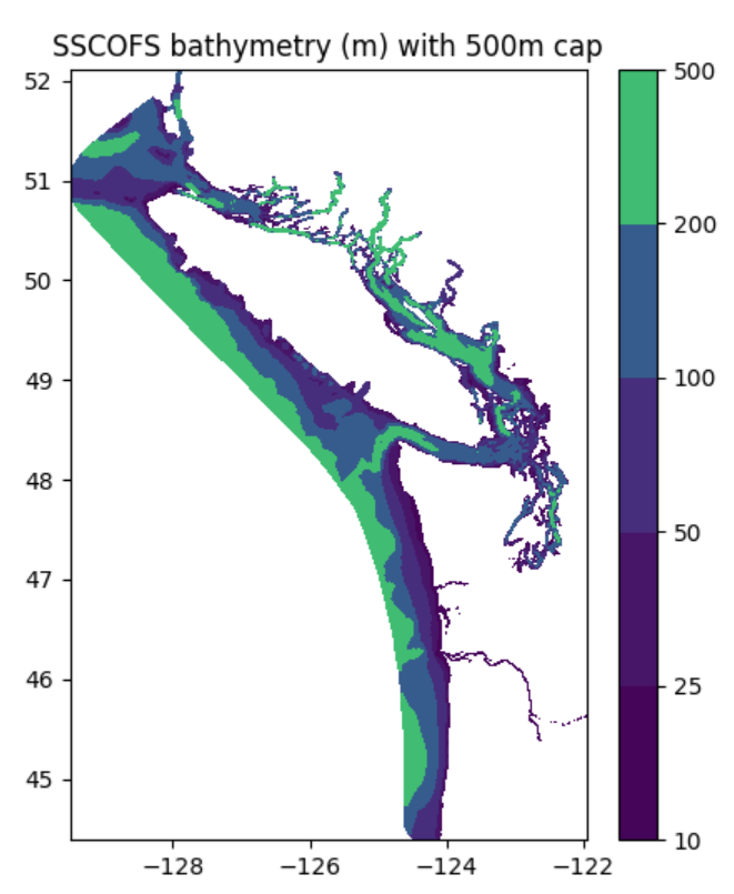
The SSCOFS grid has 239,734 nodes and 433,410 elements. The vertical grid follows the terrain and consists of 10 spatially varying sigma-layers. The SSCOFS model domain encompasses the Puget Sound, the San Juan Islands, the Strait of Georgia, and the Strait of Juan de Fuca, and extends south along the Pacific Coast to include the Columbia River. The model has an unstructured triangular grid. The resolution varies from ~ 100 m along the shoreline to 500 m in deeper parts of Puget Sound and the Georgia Basin, and increases to 10,000 m over the continental shelf. Resolution in the Columbia River varies between 100 and 200 m.
The SSCOFS runs on NOAA's Weather and Climate Operational Supercomputing System (WCOSS) in a Coastal Ocean Modeling Framework developed by CO-OPS. As a result, the SSCOFS has direct access to NWS operational meteorological products that it needs to run reliably.
Nowcast and forecast guidance cycles are run 4 times a day (every 6 hours). All SSCOFS nowcast and forecast guidance are monitored by the CO-OPS's Continuous Operational Real-Time Monitoring System (CORMS). CORMS provides 24 hour per day, 7 day per week monitoring and quality control of sensors and data in order to ensure the availability, accuracy, and quality of tide, water level, current, and other marine environmental information. CORMS is intended to identify invalid and erroneous data and information before application of the data by real-time and near real-time users.
SSCOFS output is in NetCDF format. OFS output includes time series at the selected locations (stations) at 6-minute intervals, and hourly 3-dimensional
fields for the entire model domain for water levels, currents, water temperature, and salinity.
- Stations Output Files:
- sscofs.tCCz.YYYYMMDD.stations.[nowcast|forecast].nc
- 3-Dimensional Fields Output Fields Files:
- sscofs.tCCz.YYYYMMDD.fields.[n|f]HHH.nc
- [nowcast|forecast] & [n|f]
- denote either the nowcast or forecast results
- HHH
- is the nowcast or forecast hour; range from 000 to 006 for SSCOFS nowcasts and range from 000 to 072 for SSCOFS forecasts
- YYYYMMDD
- is the date of the model run
- CC
- is the model cycle of the day; 03, 09, 15 and 21 for SSCOFS
- For the most recent 24 hours: full dataset
- NOMADS Data at NCEP: https://nomads.ncep.noaa.gov/pub/data/nccf/com/nosofs/prod/
- NCEP FTP: ftp://ftp.ncep.noaa.gov/pub/data/nccf/com/nosofs/prod/
Access the FTP site from a Windows File Explorer window.
- For the most recent 31 days only: full dataset
- CO-OPS THREDDS Data Service (operational version):
https://opendap.co-ops.nos.noaa.gov/thredds/catalog.html - CO-OPS FTP: ftp://tidepool.nos.noaa.gov/pub/outgoing/ofs
Access the FTP site from a Windows File Explorer windows.
- CO-OPS THREDDS Data Service (operational version):
- For the most recent 2 years (with a 3-day delay): 3-dimensional nowcast files and 60 days of
3-dimensional forecast files (no stations files)
- Amazon Web Services: https://noaa-nos-ofs-pds.s3.amazonaws.com/index.htm
You will need to build a script to aggregate/subset the output and derive properties that you're interested in. More information on accessing the data on this archive can be found here:
https://github.com/awslabs/open-data-docs/tree/main/docs/noaa/noaa-ofs-pds
- Amazon Web Services: https://noaa-nos-ofs-pds.s3.amazonaws.com/index.htm
- For the most recent 5+ years (with a 3-day delay): 3-dimensional nowcast files and stations nowcast and forecast files (no 3-dimensional forecast files)
- NCEI THREDDS: https://www.ncei.noaa.gov/thredds/catalog/model/model.html
- NCEI Web Service: https://www.ncei.noaa.gov/data/operational-nowcast-and-forecast-hydrodynamic-model-systems-co-ops/access/ These archives also contain files from retired OFS such as NGOFS, NEGOFS, NWGOFS.


