West Coast Operational Forecast System (WCOFS)
Oceanographic nowcast and forecast guidance are scientific predictions about the present and future states of a water body (generally including water levels, currents, water temperature and salinity). These predictions rely on either observed data or forecasts from large-scale numerical models. A nowcast incorporates recent (and often near real-time) observed meteorological, oceanographic, and/or river flow rate data and/or analyzed (e.g. gridded) meteorological and oceanographic products. A nowcast covers the period of time from the recent past (e.g., the past few days) to the present, and it can make predictions for locations where observational data are not available. Forecast guidance incorporates meteorological, oceanographic, and/or river flow rate forecasts and makes predictions about the future states of a water body. A forecast is usually initiated by the state of a nowcast.
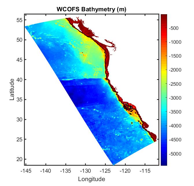
The WCOFS is based on the Regional Ocean Modeling System (ROMS). The WCOFS domain encompasses the entire west coast from California to Washington and extends offshore for more than 1000 km. The model grid has 348x1016 points in the horizontal with grid resolution of about 4 km. The vertical grid follows the terrain and consists of 40 levels. In the WCOFS Model Grid graphic below, only every tenth grindline is plotted. The bathymetry of the WCOFS model (shown in the figure to the left) includes a black contour line depicting the 1000 m isobath.
The WCOFS has three open-ocean boundaries (north, south and west). NCEP's Global Real Time Ocean Forecast System (RTOFS) is used to provide open boundary conditions for non-tidal water level, temperature, salinity, and non-tidal depth integrated currents. Tidal currents and water level are constructed from Oregon State University's TPXO8 tidal database. Temperature and salinity within a 100km zone along the open boundary are also nudged towards RTOFS temperature and salinity fields.
Meteorological surface forcing conditions are derived from the National Weather Service's (NWS) North American Mesoscale 12 km atmospheric forecast model data. Operational products from the NWS Global Forecasting System (FV3GFS) serve as the backup meteorological surface forcing conditions in the case of NAM products are not available for both the nowcast and forecast runs. Additionally, the WCOFS uses USGS real-time river discharge observations for Columbia River and climatology discharge and temperature for 14 rivers in Washington and Fraser River in Canada during nowcast. River discharge and temperature are held constant from the last observation throughout the forecast period.
The WCOFS nowcast/forecast starts with analysis from a 3-day data assimilation window. ROMS's four dimensional variational data assimilation (4DVAR) methodology is used to improve the initial conditions of the ocean state. Currently, the following observations are assimilated: 3-satellite sea surface temperature (SST) (the Visible Infrared Imaging Radiometer Suite (VIIRS) onboard the Suomi National Polar-Orbiting Partnership, VIIRS from NOAA-20, and Advanced Baseline Imager from GOES-17), surface currents from the National High Frequency Radar (HFR) network, and absolute dynamic topography (ADT) from satellites Jason 3, Sentinel 3, Cryosat 2, and SARAL/Altika. The figure below shows a sample of satellite observations which were assimilated in a 3-day data assimilation window by WCOFS.
The WCOFS runs on NOAA's High Performance Computers (HPC) in the Coastal Ocean Modeling Framework (COMF) developed by CO-OPS. As a result, WCOFS has direct access to NWS operational meteorological products that it needs to run reliably. Nowcast and forecast guidance cycles are run daily with 24-hour nowcast and 72-hour forecast.
The WCOFS output is in Climate and Forecast conventions compliant NetCDF format (CF compliant NetCDF). Its outputs include time series at the selected locations (stations) at 6-minute intervals, hourly surface 2-D fields, and 3-hourly 3-D fields for the entire model domain for water levels, currents, water temperature, and salinity. The naming conventions for each type of output are listed below:
Stations: nos.wcofs.stations.[nowcast|forecast]. YYYYMMDD.tCCz.nc
2-D surface field output: nos.wcofs.2ds.[n|f]HHH.YYYYMMDD.tCCz.nc
3-D field output: nos.wcofs.fields.[n|f]NNN.YYYYMMDD.tCCz.nc
On March 27, 2024, the names of the OFS output files will be changed to:
Stations: wcofs.t[CC]z.[YYYYMMDD].stations.[nowcast|forecast].nc
2-D surface field output: wcofs.t[CC]z.[YYYYMMDD].2ds.[n|f][HHH].nc
3-D field output: wcofs.t[CC]z.[YYYYMMDD].fields.[n|f][HHH].nc
3-D field output on a regular grid: wcofs.t[CC]z.[YYYYMMDD].regulargrid.[n|f][HHH].nc
Where [nowcast/forecast] or [n/f] denotes either the nowcast or forecast results; YYYYMMDD is the date of the model run, tCCz is the cycle of the day; HHH is the nowcast or forecast hour.
An archive of WCOFS NetCDF nowcast and forecast files are accessible from the CO-OPS THREDDS server.
All CO-OPS official real-time products, including nowcast and forecast guidance from WCOFS are monitored by the CO-OPS's Continuous Operational Real-Time Monitoring System (CORMS). CORMS provides 24 hour per day, 7 day per week monitoring and quality control of sensors and data in order to ensure the availability, accuracy, and quality of water level, current, and other marine environmental information. CORMS is intended to identify invalid and erroneous data and information before application of the data by real-time and near real-time users.


